Property Record
4130 Highway 411 Ne, Rydal, GA 30171
NEARBY LISTINGS FOR SALE OR LEASE
Property Detail
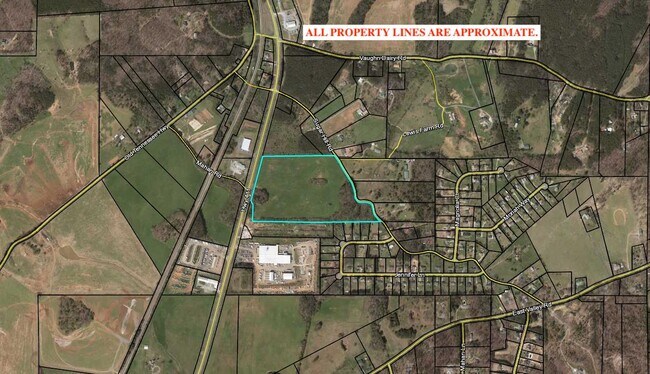
4130 Highway 411 Ne
0104-0291-005
LLS 290&291 D 22 S 2
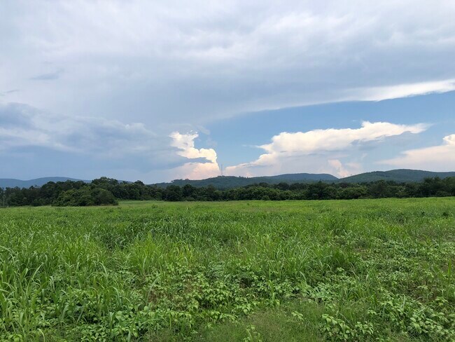
Agriculturalland
Bartow
X
Georgia
13057C0125E
26.54 AC
2024
Bartow County
2025
Atlanta
960104
Atlanta-Sandy Springs-Roswell, GA
DEMOGRAPHICS near 4130 Highway 411 Ne
1 Mile
3 Mile
5 Mile
2024 Total Population
817
2,759
5,599
2029 Population
899
3,022
6,100
Pop Growth 2024-2029
+ 10.04%
+ 9.53%
+ 8.95%
Average Age
40
40
40
2024 Total Households
286
975
1,998
HH Growth 2024-2029
+ 9.79%
+ 9.23%
+ 8.71%
Median Household Inc
$59,374
$64,449
$74,687
Avg Household Size
2.80
2.80
2.80
2024 Avg HH Vehicles
2.00
2.00
2.00
Median Home Value
$327,477
$320,331
$296,754
Median Year Built
1992
1992
1992
Nearby Places
Map Layers
Map Styles
 Street
 Aerial
- Restaurants
- Banks
- Shops
- Fitness
- Groceries
SALE & LEASE HISTORY
LISTING DATE
SALE/LEASE

Jul 16, 2020
For Sale
Nearby Properties
Address
Land Use
TOTAL SIZE
Lot Size
Zoning
Address
Land Use
TOTAL SIZE
Lot Size
Zoning
587,459 SF
146.14 AC
A1
Address
Land Use
TOTAL SIZE
Lot Size
Zoning
880,122 SF
146.14 AC
Address
Land Use
TOTAL SIZE
Lot Size
Zoning
702,946 SF
146.14 AC
I2
Address
Land Use
TOTAL SIZE
Lot Size
Zoning
262,316 SF
Address
Land Use
TOTAL SIZE
Lot Size
Zoning
393,536 SF
146.14 AC
Address
Land Use
TOTAL SIZE
Lot Size
Zoning
101,612 SF
32.53 AC
A1
Address
Land Use
TOTAL SIZE
Lot Size
Zoning
7,840 SF
81 AC
A1
Address
Land Use
TOTAL SIZE
Lot Size
Zoning
825.04 AC
Address
Land Use
TOTAL SIZE
Lot Size
Zoning
88,706 SF
18 AC
A1
Address
Land Use
TOTAL SIZE
Lot Size
Zoning
19,200 SF
4.05 AC
A1
Address
Land Use
TOTAL SIZE
Lot Size
Zoning
9,788 SF
23 AC
A1
Address
Land Use
TOTAL SIZE
Lot Size
Zoning
20,000 SF
2 AC
Address
Land Use
TOTAL SIZE
Lot Size
Zoning
1,344 SF
10.97 AC
C1
Address
Land Use
TOTAL SIZE
Lot Size
Zoning
340.01 AC
Address
Land Use
TOTAL SIZE
Lot Size
Zoning
1,446 SF
145.97 AC
Address
Land Use
TOTAL SIZE
Lot Size
Zoning
Address
Land Use
TOTAL SIZE
Lot Size
Zoning
183.60 AC
A1
Address
Land Use
TOTAL SIZE
Lot Size
Zoning
11,520 SF
3.91 AC
Address
Land Use
TOTAL SIZE
Lot Size
Zoning
6,195 SF
4 AC
Address
Land Use
TOTAL SIZE
Lot Size
Zoning
119.38 AC
Address
Land Use
TOTAL SIZE
Lot Size
Zoning
169.17 AC
A1
Address
Land Use
TOTAL SIZE
Lot Size
Zoning
9,100 SF
1.72 AC
Address
Land Use
TOTAL SIZE
Lot Size
Zoning
262.90 AC
A1
Address
Land Use
TOTAL SIZE
Lot Size
Zoning
1,442 SF
21.83 AC
A1
Address
Land Use
TOTAL SIZE
Lot Size
Zoning
267.42 AC
A1
Address
Land Use
TOTAL SIZE
Lot Size
Zoning
95.67 AC
Address
Land Use
TOTAL SIZE
Lot Size
Zoning
1,409 SF
97.56 AC
A1
Address
Land Use
TOTAL SIZE
Lot Size
Zoning
10.79 AC
IN
Address
Land Use
TOTAL SIZE
Lot Size
Zoning
3,273 SF
5.30 AC
The World's #1 Commercial Real Estate Marketplace
Connect with us
© 2026 CoStar Group
The information above has been obtained from sources believed reliable. While we do not doubt its accuracy we have not verified it and make no guarantee, warranty or representation about it. It is your responsibility to independently confirm its accuracy and completeness. Any projections, opinions, assumptions, or estimates used are for example only and do not represent the current or future performance of the property. The value of this transaction to you depends on tax and other factors which should be evaluated by your tax, financial, and legal advisors. You and your advisors should conduct a careful, independent investigation of the property to determine to your satisfaction the suitability of the property for your needs.